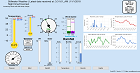
Storm Prediction Center - Convective Outlooks
|
|

Categorical Day1 Z Outlook
|
|

Probability of a tornado within 25 miles of a point.
Hatched Area: 10% or greater probability of EF2 - EF5 tornadoes within 25 miles of a point.
|
|

Probability of one inch diameter hail or larger within 25 miles of a point.
Hatched Area: 10% or greater probability of two inch diameter hail or larger within 25 miles of a point.
|
|

Probability of damaging thunderstorm winds or wind gusts of 50 knots or higher within 25 miles of a point.
Hatched Area: 10% or greater probability of wind gusts 65 knots or greater within 25 miles of a point.
|
|
|
Images courtesy of the NWS Storm Prediction Center
Weather Forecast
Discussion
700
FXUS64 KOUN 151144
AFDOUN

Area Forecast Discussion
National Weather Service Norman OK
644 AM CDT Wed Jul 15 2026

...New AVIATION...

.KEY MESSAGES...
Updated at 643 AM CDT Wed Jul 15 2026

- Showers and thunderstorms possible through Friday. Some of the
  storms may become strong.

- Slightly below normal temperatures expected through the end of
  the week before triple digit heat returns over the weekend.

&&

.NEAR TERM...
(Through Wednesday)
Issued at 148 AM CDT Wed Jul 15 2026

There is a very low chance for an isolated shower or two to develop
but most, if not all of the fa, is expected to remain dry overnight
into early Wednesday. With light winds and low temp/dewpoint spreads
expected, patchy fog development will be possible once again early
Wednesday morning with the best chance in parts of north TX and
southern OK although patchy fog could extend northward into parts of
central OK. If this fog develops, it is expected to dissipate by mid-
morning.

Models show a mid-lvl shortwave/disturbance moving east to west
across the area Wednesday bringing a chance for isolated to
scattered showers and storms to parts of the fa. The highest chances
will be in eastern portions of the fa, generally along and east of I-
35, mostly during the afternoon hours. With MLCAPE expected to be in
the 1000-2000 J/kg range, some of the storms could become strong
Wednesday afternoon with gusty winds and small hail. The showers and
storms are expected to decrease Wednesday evening with the loss of
heating.

The near to below average temperatures are expected to continue
Wednesday with afternoon highs in the upper 80s to low 90s.

&&

.SHORT TERM...
(Wednesday night through Friday night)
Issued at 148 AM CDT Wed Jul 15 2026

Models show the upper high continuing to shift into the Mid-Atlantic
states Wednesday which will shift the upper flow to more southerly
for the end of the work week. Models show a couple of mid-lvl
disturbances moving south to north across the Southern Plains which
will bring rain chances to parts of the fa both Thursday and Friday.

With southerly flow returning to the area, temperatures may be a
degree or two warmer at the end of the week although cloud cover and
rain is expected to still keep them near or just below average for
mid July with highs in the upper 80s to low/mid 90s.

&&

.LONG TERM...
(Saturday through Tuesday)
Issued at 148 AM CDT Wed Jul 15 2026

Models show the upper high building across the western U.S. possibly
into the Southern Plains over the weekend into early next week with
NW flow possibly setting up over the Northern/Central Plains next
week. At the sfc, south to southwesterly winds are expected over the
weekend. Models are now showing the potential for a frontal boundary
to move into at least parts of the fa early to middle of next week.

With the upper ridge potentially influencing the area and south to
southwesterly flow at the sfc, temperatures are expected to warm
over the weekend into early next week with a return to above normal
temperatures with highs in the mid/upper 90s and low 100s. However,
temperatures may be knocked down a few degrees next week if the
previously mentioned frontal boundary moves into the area.

A drier forecast is also expected over the weekend into early next
week with the upper ridge providing less of an opportunity for storm
development. One chance for some more rain may also be with the
frontal boundary next week.

&&

.AVIATION...
(12Z TAFS)
Issued at 643 AM CDT Wed Jul 15 2026

Some fog has developed at KADM at the base of the Arbuckle
Mountains, but is so far confined there. Satellite does now show
any significant areas of fog this morning. Scattered showers and
thunderstorms are expected this afternoon, mainly across the
eastern part of the forecast area.

&&

.PRELIMINARY POINT TEMPS/POPS...
Oklahoma City OK  89  70  90  71 /  30  20  10  10
Hobart OK         90  68  90  69 /  20  20  10  10
Wichita Falls TX  92  69  91  70 /  10  10  30  20
Gage OK           91  67  92  68 /  20  10   0   0
Ponca City OK     89  71  90  73 /  30  10  10   0
Durant OK         90  72  90  73 /  30  20  20  10

&&

.OUN WATCHES/WARNINGS/ADVISORIES...
OK...None.
TX...None.
&&

$$

NEAR TERM...25
SHORT TERM...25
LONG TERM....25
AVIATION...13
NWS OUN Office Area Forecast Discussion


