| |
Today |
Yesterday |
| High |
71.0°F
@ 9:59am |
77.6°F
@ 6:03pm |
| Low |
52.6°F
@ 6:34am |
41.7°F
@ 6:46am |
|
|

|
Sunny, Dry
|

|
Wind:
S
4.9
Gusting to:
2.0 mph
|
 |
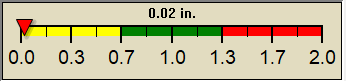
Rain:
0.00 in
|

|
Current CBI
Fire Danger:
13.0 of 100
|
Humidity
 56 %
56 %
|
Barometer
29.929 inHg
|
|
| Stillwater Weather Forecast -
Outlook Today & Tonight |
Today

Sunny then Showers And T-Storms Likely
Hi 85 °F |
NWS forecast: Showers and thunderstorms likely after 4pm. Sunny. High near 85, with temperatures falling to around 81 in the afternoon. Southwest wind 8 to 14 mph, with gusts as high as 21 mph. Chance of precipitation is 60%. New rainfall amounts between a tenth and quarter of an inch possible.
|
Tonight

Showers And T-Storms Likely then Partly Cloudy
Lo 52 °F |
NWS forecast: Showers and thunderstorms likely before 7pm, then a slight chance of showers and thunderstorms between 7pm and 10pm. Partly cloudy, with a low around 52. Northwest wind 0 to 8 mph. Chance of precipitation is 60%. New rainfall amounts between a tenth and quarter of an inch possible. |
|
| Short Term Weather Forecast For Stillwater |
Saturday

Mostly Sunny
Hi 84 °F |
Saturday
Night

Chance Showers And T-Storms
Lo 59 °F |
Sunday

Showers And T-Storms
Hi 73 °F |
Sunday
Night

Chance Showers And T-Storms then Mostly Clear
Lo 45 °F |
Monday

Sunny
Hi 78 °F |
Monday
Night

Clear
Lo 56 °F |
Tuesday
Sunny
Hi 90 °F |
|
Fully detailed forecast here.
NWS forecast for Stillwater, OK updated Fri, 05-08-2026 7:56am CDT.
Forecast script from Saratoga-Weather.org |
|
|
| Dew Point |
Liquid Precipitation |
Wind Speed |
Sun/Moon |
| Current: |
 54.5°F
|
| Last Hour: |
+0.9°F
|
| High 9:48 AM: |
55.5°F
|
| Low 12:52 AM: |
45.0°F
|
| Record High: |
83.7°F on
Jul-27-2025 |
| Record Low: |
-1.8°F on
Jan-23-2026 |
| Wetbulb: |
61.6°F
|
|
Rain Today
|
|
Today:
|
0.00 in
|
| Yesterday: |
0.00 in
|
| Last 7 Days: |
0.00 in
|
| May Rain: |
0.00 in
|
May to Date
Avg:10
|
0.00 in
|
May to Date
Diff from Avg:10
|
 0.00 in 0.00 in
|
| May Avg: |
6.13 in
|
| Diff from Avg: |
6.13 in
|
| Season:1 |
4.65 in
|
YTD
Avg:11
|
6.76 in
|
YTD
Diff from Avg:11
|
2.11 in
|
Last Rain
Time/Date: |
Apr-26-2026
at 7:52 AM |
|
22 rain days in 2026 |
0 days in May
11 days since last rain |
|
| Current: |
S
4.9 mph
|
| 1Hr Average: |
3.2 mph
|
| Wind Run: |
15.37 miles
|
|
Wind Gust |
| Current: |
2.0 mph
|
| Today: |
14.0 mph 9:49 AM
|
| Month: |
24.0 mph
May-4 |
| Year: |
38.0 mph
Mar-15 |
| Record Gust: |
38.0 mph
Mar-15-2026 |
|
Sunlight:
13 h 51 m 57 s
of Sunlight Yesterday
13 h 53 m 46 s
of Sunlight Today
Which is
1 min 49 sec longer than
yesterday
13 h 55 m 32 s
of Sunlight Tomorrow
(Noon ?>)
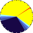 (Midnight
|
|
Waning Gibbous
|

|
62%
Illuminated |
|
| Humidity |
Barometer |
| Current: |
56%
|
| Last Hour: |
11% |
| High 6:42 AM: |
81% |
| Low 9:56 AM: |
56% |
| Record High: |
95%
Apr-27-2025 |
| Record Low: |
14%
Mar-20-2026 |
|
| Current: |
29.929 inHg
|
| Last Hour: |
Falling slowly
|
| High 1:03 AM: |
29.981
|
| Low 9:58 AM: |
29.928
|
| Record High: |
30.891 inHg
Dec-14-2025 |
| Record Low: |
29.217 inHg
Apr-2-2025 |
|
|
Cooling Degree Days |
Snow3 |
Heat Index |
Oklahoma City Air Quality |
| Today: |
0.0 |
| May: |
11.9 |
| 2026 to Date: |
221.7 |
|
Heating Degree Days |
| 2026 to Date: |
1496.0 |
|
| Today: |
0.00 in
|
| Yesterday: |
0.00 in
|
| May Snow: |
0.00 in
|
| May Avg: |
0.00 in
|
| Diff from Avg: |
0.00 in
|
| Season Total:2 |
0.00 in
|
| Snow Depth: |
0.00 in
|
|
0 snow days in May |
|
0 snow days this season.2
|
Average 1st Snow:
0 |
|
| Current: |
76.3°F
|
| High 9:59am: |
71.0°F
|
| Yesterday: |
77.6°F
|
| Record: |
115.2°F
Aug-18-2025 |
|
Quality
Index6:
46

Density:
1.19 kg/m3 |
|
| UV Summary/Forecast |
Solar Summary Unavailable |
|
High Yest:
7.1 @ 1:24 PM
|
May-08

7.6
|
May-09
7.9
|
May-10
8.0
|
|
|
| Almanac |
Irrigation Index5 |
Station Records as of April 1, 2025 |
Cloud Level
|
| Currently: |
Morning |
| YTD Avg Temp: |
54.7°F
|
| Sunrise: |
06:26 |
| Sunset: |
20:22 |
| Moonrise: |
1:47 am |
| Moonset: |
11:44 am |
| Full Moon: |
May-01-2026 |
| New Moon: |
20:02 UTC
May-16-2026 |
|
| Updated at Midnight |
| Current ET: |
0.07 in
|
| 7-Days Rain: |
0.00 in
|
| 7-Days ET: |
1.22 in
|
|
7-Day: |
1.224 in
|
|
May: |
1.22 in
|
|
| HIGHS: |
LOWS: |
101.5°F
Jul-30-2025 |
5.2°F
Jan-26-2026 |
| Daytime Records |
100.0°F°F
Jul-30-2025 |
8.6°F°F
Jan-24-2026 |
| Nitetime Records |
86.5°F°F
Aug-10-2025 |
7.2°F°F
Jan-25-2026 |
ICN:5 | S3C2:1 | Ajax 3.07
ISS:Ok | CON:4.7 | RCP:99% |
|

|


