NOAA NWS Area Products

Select NOAA-NWS Forecast Office Text Products

(Product availability varies with seasons, forecast office, and weather.)

Local Storm Report for Norman, OK

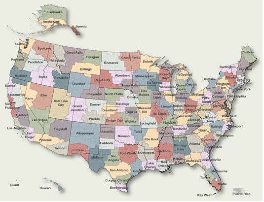
To Select Another NWS Office Click on Map or Choose from List

County Warning Area MAP
Select Forecast Office:   Select Product:  
184
NWUS54 KOUN 190647
LSROUN

Preliminary Local Storm Report
National Weather Service Norman OK
147 AM CDT Sat Apr 19 2025

..TIME...   ...EVENT...      ...CITY LOCATION...     ...LAT.LON...
..DATE...   ....MAG....      ..COUNTY LOCATION..ST.. ...SOURCE....
            ..REMARKS..

1020 PM     Tstm Wnd Dmg     1 N Leon                33.88N 97.43W
04/18/2025                   Love               OK   Emergency Mngr

            Approx. 3ft diameter tree downed near corner
            of Buchanan Circle and Commerce Ave. Radar
            estimated time.

1030 PM     Tstm Wnd Dmg     3 NNE Burneyville       33.95N 97.28W
04/18/2025                   Love               OK   Emergency Mngr

            Small storage shed toppled over east of the
            intersection of Dixon and Eastman RD. Time
            estimated from radar.

1145 PM     Hail             5 SE Newcastle          35.19N 97.55W
04/18/2025  E0.75 Inch       McClain            OK   Public

            Report from mPING: Dime (0.75 in.).

1147 PM     Hail             5 S Moore               35.27N 97.50W
04/18/2025  E1.00 Inch       Cleveland          OK   NWS Employee


1148 PM     Hail             3 SSW Moore             35.31N 97.51W
04/18/2025  M1.38 Inch       Cleveland          OK   Trained Spotter


1149 PM     Hail             4 S Moore               35.29N 97.51W
04/18/2025  E1.25 Inch       Cleveland          OK   Public

            Report from mPING: Half Dollar (1.25 in.).

1151 PM     Hail             3 SW Moore              35.30N 97.52W
04/18/2025  E1.25 Inch       Cleveland          OK   Public

            Report from mPING: Half Dollar (1.25 in.).

1152 PM     Hail             2 SW Moore              35.31N 97.52W
04/18/2025  E1.50 Inch       Cleveland          OK   Broadcast Media

            At Oak Ridge Elementary School.

1156 PM     Hail             2 W Moore               35.35N 97.52W
04/18/2025  E1.00 Inch       Cleveland          OK   Public

            Report from mPING: Quarter (1.00 in.).

1227 AM     Hail             3 SW Stillwater         36.09N 97.10W
04/19/2025  E1.50 Inch       Payne              OK   Public

            Report from mPING: Ping Pong Ball (1.50
            in.).

1228 AM     Hail             3 SSE Ada               34.73N 96.64W
04/19/2025  E1.25 Inch       Pontotoc           OK   Public


&&

$$

Previous Local Storm Reports may be found at
NWS Norman, OK (OUN) Office Local Storm Reports.
(Click 'Previous Version' there to view past versions successively.
Some may differ only in time posted.)

San Juan, PRHonolulu, HI Lake Charles, LA Pueblo, CO Corpus Christi, TX St. Louis, MO Reno, NV Raleigh, NC  Newport/Morehead City, NC Dodge City, KS Houston/Galveston, TX San Joaquin Valley/Hanford, CA Louisville, KY Fort Worth, TX Pittsburgh, PA Austin/San Antonio, TX Sacramento, CA Jackson, MS Phoenix, AZ Northern Indiana, IN Flagstaff, AZ Tallahassee, FL Springfield, MO Riverton, WY Blacksburg, VA Sioux Falls, SD El Paso Area, NM Columbia, SC Wilmington, NC Greenville-Spartanburg, SC Eureka, CA Midland/Odessa, TX Tucson, AZ Goodland, KS Huntsville, AL Amarillo, TX Norman, OK Lubbock, TX Marquette, MI Little Rock, AR Pendleton, OR Missoula, MT Binghamton, NY Boston, MA Green Bay, WI Billings, MT Baltimore/Washington San Diego, CA Tampa Bay, FL Morristown, TN Twin Cities, MN Brownsville, TX Portland, OR Des Moines, IA Memphis, TN Pocatello, ID San Angelo, TX Jacksonville, FL Aberdeen, SD Quad Cities, IA/IL Charleston, SC New Orleans/Baton Rouge, LA Peachtree City, GA Shreveport, LA Grand Rapids, MI Medford, OR Albany, NY Wichita, KS Gray/Portland, ME Spokane, WA Boise, ID Denver/Boulder, CO Great Falls, MT Caribou, ME Key West, FL Miami-South Florida, FL New York City/Upton, NY Melbourne, FL Hastings, NE Paducah, KY Glasgow, MT Bismarck, ND Charleston WV Omaha/Valley, NE Buffalo, NY Jackson, KY Kansas City/Pleasant Hill, MO Gaylord, MI Cheyenne, WY Grand Forks, ND Detroit/Pontiac, MI Central Illinois, IL Burlington, VT Salt Lake City, UT Topeka, KS Nashville, TN Milwaukee/Sullivan, WI Albuquerque, NM Las Vegas, NV Wakefield, VA La Crosse, WI Birmingham, AL Los Angeles/Oxnard, CA Chicago, IL Seattle, WA Rapid City, SD Indianapolis, IN Philadelphia/Mount Holly, PA Mobile/Pensacola State College, PA Cleveland, OH Elko, NV Wilmington, OH Grand Junction, CO North Platte, NE Tulsa, OK San Francisco/Monterey Bay Area, CA Duluth, MN Anchorage, AK Fairbanks, AK Juneau, AK Tiyan, GU

Products Courtesy of NOAA-NWS
NWS Information Parsing Script by Ken True at Saratoga Weather - WFO and Products Scripts by SE Lincoln Weather.
Mapping by Curly at Michiana Weather and by Tom at My Mishawaka Weather.