| |
Today |
Yesterday |
| High |
73.7°F
@ 1:44am |
87.3°F
@ 4:18pm |
| Low |
70.7°F
@ 12:00am |
62.6°F
@ 8:23am |
Sta* High
89.2°F
2012 |
Sta* Low
39.7°F
2017 |
|
* This Station's Records Since 1/2012 |
|
|

|
Mostly cloudy
|

|
Wind:
S
8.1
Gusting to:
7.0 mph
|
 |
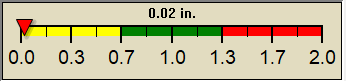
Rain:
0.00 in
|

|
Current CBI
Fire Danger:
1.1 of 100
|
|
Overnight

Partly Cloudy
|
Saturday

Chance Showers And T-Storms
|
Saturday
Night

Showers And T-Storms
|
Sunday

Showers And T-Storms Likely
|
Sunday
Night

Slight Chance Showers And T-Storms then Mostly Clear
|
Monday

Mostly Sunny then Slight Chance Showers And T-Storms
|
Monday
Night
Slight Chance Showers And T-Storms then Mostly Clear
|
|
Lo 67°F |
Hi 80°F ↓ |
Lo 59°F |
Hi 80°F |
Lo 54°F |
Hi 80°F |
Lo 60°F |
 7 Day Forecast Details 7 Day Forecast Details
|
|
| Dew Point |
Liquid Precipitation |
Wind Speed |
Sun/Moon |
| Current: |
 67.0°F
|
| Last Hour: |
+0.6°F
|
| High 1:38 AM: |
67.4°F
|
| Low 12:00 AM: |
66.0°F
|
| Record High: |
86.0°F on
Aug-5-2023 |
| Record Low: |
-11.7°F on
Jan-14-2024 |
| Wetbulb: |
69.4°F
|
|
Rain Today
|
|
Today:
|
0.00 in
|
| Storm Rain: |
0.20 in
|
| Yesterday: |
0.06 in
|
| Last 7 Days: |
0.20 in
|
| Apr Rain: |
1.50 in
|
Apr to Date
Avg:10
|
0.00 in
|
Apr to Date
Diff from Avg:10
|
1.50 in
|
| Apr Avg: |
0.13 in
|
| Diff from Avg: |
1.37 in
|
| Season:1 |
4.47 in
|
YTD
Avg:11
|
1.53 in
|
YTD
Diff from Avg:11
|
2.94 in
|
Last Rain
Time/Date: |
Apr-26-2024
at 5:55 AM |
|
26 rain days in 2024 |
7 days in April
0 days since last rain |
|
| Current: |
S
8.1 mph
|
| 1Hr Average: |
6.8 mph
|
| Wind Run: |
12.59 miles
|
|
Wind Gust |
| Current: |
7.0 mph
|
| Today: |
21.0 mph 12:04 AM
|
| Month: |
34.0 mph
Apr-6 |
| Year: |
34.0 mph
Apr-6 |
| Record Gust: |
34.0 mph
Apr-6-2024 |
|
Sunlight:
13 h 34 m 50 s
of Sunlight Yesterday
13 h 36 m 52 s
of Sunlight Today
Which is
2 min 2 sec longer than
yesterday
13 h 38 m 53 s
of Sunlight Tomorrow
(Noon ?>)
 (Midnight
|
|
Waning Gibbous
|

|
89%
Illuminated |
|
| Humidity |
Barometer |
| Current: |
 80% 80%
|
| Last Hour: |
4% |
| High 12:00 AM: |
85% |
| Low 1:38 AM: |
80% |
| Record High: |
96%
Jan-24-2024 |
| Record Low: |
18%
Feb-21-2024 |
|
| Current: |
29.667 inHg
|
| Last Hour: |
Steady
|
| High 1:34 AM: |
29.672
|
| Low 12:00 AM: |
29.658
|
| Record High: |
30.755 inHg
Jan-20-2024 |
| Record Low: |
29.347 inHg
Jan-8-2024 |
|
|
Cooling Degree Days |
Snow3 |
Heat Index |
Oklahoma City Air Quality |
| Today: |
0.4 |
| Apr: |
71.1 |
| 2024 to Date: |
98.6 |
|
Heating Degree Days |
| 2024 to Date: |
1473.3 |
|
| Today: |
0.00 in
|
| Yesterday: |
0.00 in
|
| Apr Snow: |
 0.00 in 0.00 in
|
| Apr Avg: |
0.00 in
|
| Diff from Avg: |
0.00 in
|
| Season Total:2 |
0.00 in
|
| Snow Depth: |
0.50 in
|
|
0 snow days in April |
|
0 snow days this season.2
|
Average 1st Snow:
0 |
|
| Current: |
73.9°F
|
| High 1:44am: |
73.7°F
|
| Yesterday: |
86.4°F
|
| Record: |
127.9°F
Aug-5-2023 |
|
Quality
Index6:
52

Density:
1.17 kg/m3 |
|
| UV Summary/Forecast |
Solar Summary Unavailable |
|
High Yest:
7.8 @ 1:31 PM
|
Apr-27

8.5
|
Apr-28

6.9
|
Apr-29
7.1
|
|
|
| Almanac |
Irrigation Index5 |
Station All Time Records |
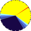
Cloud Level
|
| Currently: |
Night |
| YTD Avg Temp: |
51.1°F
|
| Sunrise: |
06:37 |
| Sunset: |
20:13 |
| Moonrise: |
11:25 pm |
| Moonset: |
8:45 am |
| Full Moon: |
Apr-23-2024 |
| New Moon: |
03:23 UTC
May-07-2024 |
|
| Updated at Midnight |
| Current ET: |
0.04 in
|
| 7-Days Rain: |
0.20 in
|
| 7-Days ET: |
1.11 in
|
|
7-Day: |
0.91 in
|
|
April: |
2.62 in
|
| Support this Site! |
|
Your donation helps support this site
|
|
| HIGHS: |
LOWS: |
104.7°F
Aug-3-2023 |
-1.1°F
Jan-15-2024 |
| Daytime Records |
103.6°F°F
Aug-03-2023 |
4.1°F°F
Jan-14-2024 |
| Nitetime Records |
88.9°F°F
Aug-04-2023 |
1.6°F°F
Jan-15-2024 |
ICN:13 | S3C2:6 | Ajax 3.07
ISS:Ok | CON:4.7 | RCP:99% |
|

|
| NWS Weather Forecast -
Outlook Overnight & Saturday |
Overnight
Partly Cloudy
Lo 67°F
|
NWS forecast: Partly cloudy, with a low around 67. South wind around 20 mph, with gusts as high as 30 mph.
Local station forecast: Mostly cloudy and cooler, windy with possible wind shift to the w, nw, or n. |
Saturday
Chance Showers And T-Storms
Hi 80°F ↓
|
NWS forecast: A chance of showers and thunderstorms between 10am and 1pm, then showers and thunderstorms. Some of the storms could be severe. Mostly cloudy. High near 80, with temperatures falling to around 74 in the afternoon. South wind 18 to 22 mph, with gusts as high as 33 mph. Chance of precipitation is 80%. New rainfall amounts between a half and three quarters of an inch possible.
|
|
| NWS Short Term Weather Forecast |
|
Saturday
Night
Showers And T-Storms
|
Sunday
Showers And T-Storms Likely
|
Sunday
Night
Slight Chance Showers And T-Storms then Mostly Clear
|
Monday
Mostly Sunny then Slight Chance Showers And T-Storms
|
Monday
Night
Slight Chance Showers And T-Storms then Mostly Clear
|
Tuesday

Sunny
|
Tuesday
Night

Slight Chance Showers And T-Storms
|
|
Lo 59°F |
Hi 80°F |
Lo 54°F |
Hi 80°F |
Lo 60°F |
Hi 88°F |
Lo 64°F |
|
ajax-dashboard6.php - Version 6.95h - 20-Feb-2023 - Script by: Scott of BurnsvilleWeatherLIVE.com
Now supported by Saratoga-weather.org Download
|


